Report from the U.S. Geological Survey reveals a drop due to farmers’ use in Southern Oregon.
BY JACOB PALMER | DIGITAL NEWS EDITOR
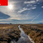
A report from the U.S. Geological Survey reveals a drop in the Klamath Basin groundwater level due to farmers’ use — and exacerbated by a decade of drought — in Southern Oregon.
It has fallen 25 feet since 2001.
But the report does not lay blame on farmers in the project. USGS Hydrologist Marshall Gannett said the story of groundwater in the Klamath basin is more complicated. Natural and climatic forces are at play, as well as irrigation and other pumping by other water users in the region.
“The pumping for the Project irrigators is one of many stresses on the groundwater system, and we can’t really tease those apart,” he said.
(SOURCE: OPB)
“Pre-2001 groundwater pumping in the area where most of this increase occurred is estimated to have been about 28,600 acre-feet per year,” the report read. “Subsequent supplemental pumping rates have been as high as 128,740 acre-feet per year. During this period of increased pumping, groundwater levels in and around the Bureau of Reclamation Klamath Project have declined by about 20–25 feet. Waterlevel declines are largely due to the increased supplemental pumping, but other factors include increased pumping adjacent to the Klamath Project and drying climate conditions.”